
Antrozous pallidus(Le Conte, 1856)
Pallid Bat
Family: Vespertilionidae
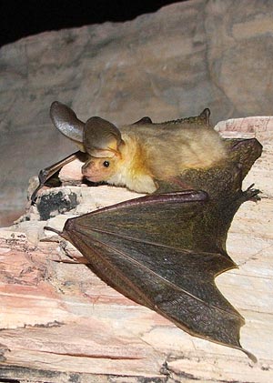 Photograph: Carson Brown
Specimens Prior to 1991
(Why two sections?)Why two different sections for specimen data?
Specimen data prior to 1991 was included in the first edition of the Bats of Texas and included only basic information. For the second edition of the book, ancillary information such as catalog number, sex, tissue numbers, etc. was collected.
Rather than mix the two sets of data into one table (which would include hundreds of empty cells for specimens prior to 1991), the two data sets were separated and formatted to best display the information.
Antrozous pallidus bunkeri
Specimens examined, 100: Oldham Co.: Griffin Ranch, 18 mi N, 1 mi W Adrian, 3 (TTU); 17 mi N, 1 mi W Adrian, 40 (TTU); Tascosa, 1 (USNM/FWS). Potter Co.: Fain Ranch, 16 mi N Amarillo, 39 (TTU). Deaf Smith Co.: 4.8 mi S, 4.9 mi E Glenrio, 4 (TTU). Collingsworth Co.: 3 mi N, 2 mi E Lutie, 1 (TTU). Briscoe Co.: 6.1 mi N, 0.1 mi W Quitaque, 1 (TTU); Caprock Canyons, 3 mi N Quitaque, 4 (TTU); Los Lingos Canyon, 2 (TTU). Haskell Co.: 8.5 mi SW Rochester, 1 (MWSU).
Additional records: Roberts Co.: 10 mi S, 15 mi E Spearman (Jones et al., 1988). Oldham Co.: 17–18 mi N, 1 mi W Adrian (Jones et al., 1988); 17–18 mi N, 1 mi E Adrian (Hollander et al., 1987); Tascosa (Bailey, 1905; Jones et al., 1988). Potter Co.: 16 mi N Amarillo (Hollander et al., 1987; Jones et al., 1988). Collingsworth Co.: 3 mi N, 12 mi E Lutie (Hollander et al., 1987). Hardeman Co.: 20 mi N Goodlett (Manning et al., 1987).
Antrozous pallidus pallidus
Specimens examined, 528: El Paso Co.: head of McKelligan Canyon, 4,700 ft., 3 (KU); Ft. Bliss, 2 (1 KU, 1 MSB); El Paso, 4 (2 FMNH, 2 USNM/FWS); 8 mi E Fabens, 4,000 ft., 4 (KU). Hudspeth Co.: Ft. Hancock, 13 (USNM/FWS); 2 mi S, 2 mi E Esperanza, 2 (UTEP); Wind Canyon, Eagle Mts., 9 (7 SRSU, 2 UTEP). Culberson Co.: McKittrick Canyon, GMNP, 13 (TCWC); Pratt Lodge, McKittrick Canyon, GMNP, 2 (TTU); South McKittrick Canyon, GMNP, 1 (TTU); Smith Springs, GMNP, 3 (TTU); The Bowl, GMNP, 4 (TTU); 4 mi E Pine Springs, GMNP, 2 (TCWC); 35 mi N Van Horn, 1 (TCWC); 25 mi N Van Horn, 1 (TCWC); Van Horn, 1 (USNM/FWS); 20 mi E Van Horn, 1 (TCWC). Reeves Co.: 3 mi WNW Toyahvale, 14 (MWSU); Toyahvale, 2 (UMMZ). Pecos Co.: 8 mi N, 1.5 mi W. Sheffield, 1 (KU); 8 mi N, 0.5 mi W Sheffield, 1 (TTU); 22.2 mi N, 1.8 mi W Marathon, 3,600 ft., 18 (TTU); 14.6 mi N, 19.2 mi E Marathon, 4,500 ft., 2 (TTU). Jeff Davis Co.: 17 mi W Balmorhea, Cherry Canyon, 1 (TCWC); 8 mi W jct. hwys. 166 and 118, 2, (SRSU); 3 mi E jct. hwys. 166 and 118, 1 (TTU); Limpia Creek, 16 mi NE Ft. Davis, 4,000 ft., 3 (TCWC); Sawtooth Mt., Davis Mts., 5,700 ft., 3 (2 DMNHT, 1 TTU); mouth of Madera Canyon, 4,400 ft., 2 (TCWC); Madera Canyon, 14 mi NW Ft. Davis, 6,000 ft., 3 (TCWC); 14 mi NE Ft. Davis, old Whittenburg ranch, 5 (LACM); Reynold’s Ranch, near Rockpile Park, Davis Mts., 4 (ASVRC); 10 mi N Ft. Davis, 2 (TTU); 8.5 mi N Ft. Davis, 8 (TTU); 6 mi NE Ft. Davis, 1 (TTU); 3.5 mi NE Ft. Davis, 2 (TTU); 1 mi N Ft. Davis, 1 (TTU); 8 mi S jct. hwys. 166 and 118, 2 (1 SRSU, 1 TTU); 5.5 mi N Mt. Livermore, 1 (TCWC); 5 mi E Mt. Livermore, 1 (UMMZ); Limpia Canyon, 3.5 mi NE Ft. Davis, 2 (TTU); Fort Davis, Hospital Canyon, 1 (UMMZ); 3 mi S Ft. Davis, 1 (TTU); Musquiz Canyon, 17.5 mi N Alpine, 1 (DMNHT); Valentine, 7 (TCWC); 3 mi E jct. hwys. 166 and 505, 1 (TTU); DMSP, 1 (TTU); 8 mi S DMSP, 1 (TTU); Fraiser Canyon, 3 (TTU); Crockett Co.: 5 mi N Iraan, Pecos River, 7 (CCSU). Terrell Co.: 15 mi SW Sheffield, 2 (MWSU); Cy Bonner Ranch, 29 mi N, 7 mi E Dryden, 3 (TCWC); 2 mi N Dryden, 6 (TCWC). Kimble Co.: Junction, Texas Tech campus, 1 (CCSU); 8 mi E Junction, 6 (MWSU). Presidio Co.: ZH Canyon, Sierra Vieja, 9 mi W Valentine, 5 (1 TCWC, 4 TTU); 8 mi NE Candelaria, 7 (TCWC); Chinati Mts., 3 (TTU); 9 mi SW Valentine, 1 (CCSU); Pinto Canyon, Chinati Mts., 45 mi SW Marfa, 18 (4 TCWC, 4 TTU, 9 SRSU, 1 UIMNH); Chinati Mts., 12 mi E Ruidosa, 5,000 ft., 1 (TCWC); Chinati Ranch, 23 mi NW Presidio, 4 (TCWC); Harper Ranch, 37 mi S Marfa, 4,000 ft., 1 (TCWC); 5 mi SE Bandera Mesa, 30 (29 MWSU, 1 NTSU); 15 mi E Redford, 1 (MWSU); 30 mi SSE Redford, 8 (MWSU); 3 mi W Lajitas, 1 (ASVRC); 2 mi W Lajitas, 3 (MWSU). Brewster Co.: 13.2 mi N, 2.6 mi E Marathon, 1 (TTU); 12.4 mi N, 2.6 mi E Marathon, 5,200 ft., 1 (TTU); 12.4 mi N, 5 mi E Marathon, 5,400 ft., 1 (TTU); 11.5 mi N, 2 mi W Marathon, 1 (TTU); 10 mi W Alpine, 3 (LACM); Alpine, 1 (USNM/FWS); Paisano, 2 (USNM/ FWS); 38 mi S, 14 mi E Marathon, 17 (11 TTU, 6 UIMNH); BGWMA, 200 (138 DMNHT, 33 LACM, 13 MSU, 4 TCWC, 12 TTU); 4 mi E jct. Maravillas Creek, Rio Grande, 1 (DMNHT); 7 mi S BGWMA, 7 (DMNHT); N base Rosillos Mts., 2 (UMMZ); Grapevine Springs, BBNP, 3,000 ft., 2 (TCWC); Oak Spring, W Side Chisos Mts., BBNP, 1 (UMMZ); Oak Creek, BBNP, 4,000 ft., 3 (2 TCWC, 1 BBNHA); Bonham Ranch, Government Springs Ranch House, BBNP, 3,950 ft., 2 (AMNH); Kibee Spring, Chisos Mts., 5,700 ft., 1 (FMNH); Terlingua Creek, 4 mi E Terlingua, 2,200 ft., 4 (TCWC); Terlingua Creek, 3 mi W Study Butte, 1 (SRSU); Nail’s Ranch, E side Burro Mesa, BBNP, 3,500 ft., 9 (1 LACM, 3 MVZ, 5 TCWC); 1.5 mi NW Boquillas, BBNP, 1 (UMMZ); Boquillas Ranger Station, BBNP, 5 (4 TTU, 1 BBNHA); Boquillas, 1 (USNM/FWS); Rio Grande Village, BBNP, 1 (BBNHA); mouth of Santa Elena Canyon, BBNP, 2,100 ft., 8 (TCWC); Mariscal Mine, 1 (BBNHA); Johnson’s Ranch, Rio Grande, BBNP, 2,100 ft., 3 (TCWC); K-bar Ranch, BBNP, 1 (TCWC); BBNP, 5 (TTU); Big Bend of the Rio Grande, 2,000 ft., 1 (MVZ). Val Verde Co.: Juno, 14 (MWSU); 1 mi E Langtry, 4 (CCSU); Painted Cave, mouth Devil’s River, 12 (USNM/FWS); Comstock, 21 (USNM/FWS). Kerr Co.: Camp Mystic, 24 mi NNW Kerrville, 14 (TCWC); 8 mi SW Kerrville on Turtle Creek, 1 (TCWC). Uvalde Co.: 25.0 mi NW Uvalde, Cal Newton Ranch, 2 (TCWC). Cameron Co.: 6 mi SE Brownsville, palm grove, 1 (TTU).
Additional records: Culberson Co.: 18 mi NW Kent (Baker and Patton, 1967). Upton Co.: 3 mi S, 5 mi E McCamey (Manning et al., 1987). Pecos Co.: 12 mi E Ft. Stockton (Baker and Patton, 1967). Jeff Davis Co.: 13 mi S Kent (Walton and Siegel, 1966). Crockett Co.: 5 mi N, 4 mi W Iraan (Manning et al., 1987). Kimble Co.: Texas Tech Univ. Center at Junction (Manning et al., 1987); 1 mi S Texas Tech Univ. Center at Junction (Manning et al., 1987); 5 mi S Texas Tech Univ. Center at Junction (Manning et al., 1987); 17 mi SE Junction (Manning et al., 1987). Brewster Co.: 21 mi S Alpine (Walton and Siegel, 1966); Giant Dagger Yucca Flats (Easterla, 1968). Kerr Co.: Kerrville (Blair, 1952); 16 mi S Kerrville (Muliak, 1943). Kinney Co.: no specific locality (Davis, 1974).
Specimens After 1991
Download this information in CSV format(What is CSV format?)What is CSV format?
CSV stands for "comma seperated values". It is a format that allows spreadsheet and database programs to easily import data for further use. Download specimen data in CSV format for viewing in your spreadsheet or database program.